Complete Technical Guide to Navigation & Orientation on the Salkantay Trek
High-altitude trekking navigation without mistakes
The Salkantay Trek is not a regulated trail like the Classic Inca Trail. While the main path is usually clear, there are:
- Route variants
- Camp detours
- Connections toward Santa Teresa
- Trail forks
- Sections with reduced visibility
If you hike with an agency, the guide handles navigation. But if you’re going independently — or simply want backup security — maps, GPS, and digital tracks are essential tools.
This is a structured, practical, and technical guide to help you navigate responsibly in high mountain terrain.
🏔️ 1️⃣ Why Navigation Matters on Salkantay
The route:
- Crosses 4,600+ meters at Salkantay Pass
- Experiences sudden weather shifts
- Can have dense fog
- Includes secondary and unofficial paths
- Often lacks cell service
In low visibility conditions, digital reference can prevent wrong turns or dangerous detours.
🗺️ 2️⃣ Types of Maps You Should Use
📌 A. Topographic Maps (Highly Recommended)
Best option for mountain terrain.
They show:
- Contour lines
- Elevation changes
- Rivers and streams
- High points
- Campsites
- Settlements
Advantage:
They allow you to anticipate steep climbs and manage energy properly.
🗂️ B. General Tourist Maps
Usually include:
- Trek stages
- Main camps
- Approximate distances
Useful for planning, but not sufficient for technical navigation.
📄 C. Printed Paper Map (Strongly Recommended)
Even if you rely on GPS, always carry:
- A printed overview map
- Marked main stages
- Alternative routes highlighted
Technology fails. Paper doesn’t depend on batteries.
📱 3️⃣ Using Phone GPS (Without Cell Signal)
Important fact:
📍 GPS works without internet.
Your phone can display your real-time location if:
- Maps are downloaded offline
- GPS is enabled
- You have battery power
Especially useful at:
- Abra Salkantay
- Foggy sections
- Confusing forks
- Santa Teresa junctions
🛰️ 4️⃣ Recommended Trekking Apps
These allow offline maps and GPX import:
Gaia GPS
- Detailed topographic maps
- GPX import
- Excellent for mountain terrain
AllTrails
- Community-uploaded routes
- Elevation profiles
- Offline maps (paid version)
Komoot
- Stage planning
- Turn-by-turn navigation
- Good for defined trails
Maps.me
- Free offline maps
- Less detailed topography
- Good as basic backup
📌 Download everything before leaving Cusco.
📂 5️⃣ Digital Tracks (GPX / KML): What They Are & How to Use Them
A GPX file contains:
- Exact route coordinates
- Elevation profile
- Waypoints
- Intermediate markers
How to use:
1️⃣ Download before the trek
2️⃣ Import into your app
3️⃣ Activate offline maps
4️⃣ Follow your live position relative to the track line
This allows you to see instantly if you’ve deviated.
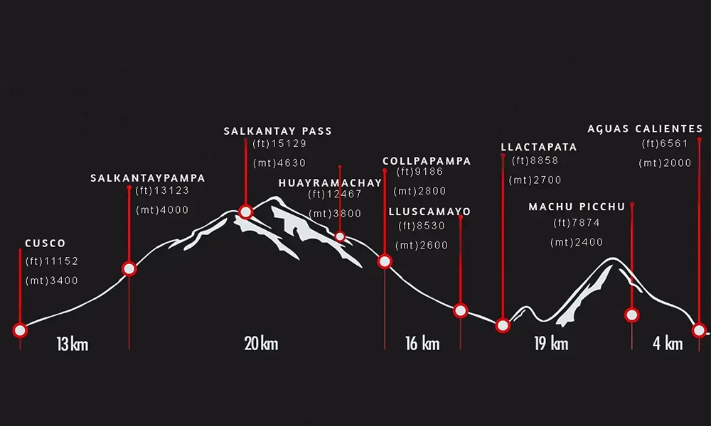
📈 6️⃣ Elevation Profile: Strategic Tool
Every GPX track includes an altitude graph.
It helps you:
- Know how far to the highest point
- Identify long climbs
- Plan breaks
- Estimate remaining effort
On Salkantay, accumulated elevation gain is a major fatigue factor.
🔋 7️⃣ Battery Management in High Altitude
Cold drastically reduces battery life.
Best practices:
- Carry a power bank
- Keep phone close to your body
- Use airplane mode
- Lower screen brightness
- Close background apps
GPS drains battery — use it strategically, not constantly.
🧭 8️⃣ Dedicated GPS vs Smartphone
📱 Smartphone
Advantages:
- Lightweight
- Multifunctional
- Easy interface
Limitations:
- Limited battery
- Sensitive to cold/moisture
🛰️ Dedicated GPS (e.g., Garmin)
Advantages:
- Longer battery life
- Rugged design
- Higher precision
Best for:
- Frequent trekkers
- Professional navigation
- Harsh weather conditions
For most travelers, a phone with offline maps is sufficient.
📍 9️⃣ Key Waypoints to Mark Before Starting
Save coordinates for:
- Soraypampa
- Abra Salkantay
- Main camps
- Humantay Lake junction
- Santa Teresa
- Hydroelectric
- Aguas Calientes
If you lose the main trail, these reference points help reorient.
⚠️ 🔟 Real GPS Limitations
GPS does NOT replace:
- Personal judgment
- Mountain experience
- Local information
- Professional guidance
In case of:
- Severe storms
- Landslides
- Trail closures
- Route modifications
Safety always overrides following a digital line.
Quick Comparison Table
| Tool | Accuracy | Needs Battery | Needs Signal |
|---|---|---|---|
| Printed Map | Medium | No | No |
| Phone GPS (offline) | High | Yes | No |
| Dedicated GPS | Very High | Yes | No |
| Online Map | High | Yes | Yes |
Best strategy: paper map + offline GPS combination.
🎯 Final Strategic Conclusion
Using maps, GPS, and digital tracks on the Salkantay Trek adds a critical layer of safety — especially for independent hikers.
The key principles:
- Download everything before departure
- Manage battery wisely
- Combine digital tools with mountain awareness
- Never rely exclusively on technology
Responsible navigation in high altitude is a balance of preparation, common sense, and the right tools.
In the Andes, technology supports you — but judgment protects you. 🏔️


")
